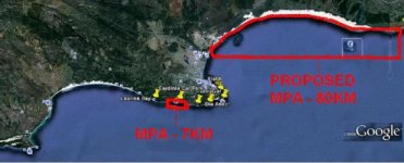
I'm all for MPA's, but are they really what we think they are ? And through other methods (like the beach driving ban and inaccessable areas) MPA's are inderectly created aswell ...
I talked about this yesterday in another thread. All this is based on Rock and Surf Fishing using fairly straight line measurements on Google Earth in the PE area.
a fairly dedicated angler (not the extreme anglers) will be willing to travel up to about 100km in a direction to go fishing, so it's 200km travelling for the day.
in PE, that would roughly be up to Port Alfred in the one direction and up to St Francis in the other direction (both are actually a little further than 100km), but are good markers for the example.
Just some calculations
Using Cape Receive Point as the starting point in both directions (note that Cape Receive is a nature reserve, a permit is required to enter and fish)
St Francis Direction :
Cape Receive to start of Sardinia Bay MPA - 17.6km
Sardinia Bay MPA - 7km
End of MPA to St Francis Light House - 79km
as a note, 60km from St Francis at StormsRiver we have ANOTHER MPA, coastline distance measures about 60km aswell.
Port Alfred Direction :
Cape Receive Point to PE Harbour - 10km
PE Harbour Area (not allowed to fish) - 4.6km
Harbour Area to Swartkops Mouth - 10km
Swartkops Mouth to "proposed MPA" - about 4km
MPA (Port Alfred Direction - 80km
So the totals
Receive to St Francis : 103.6 km
Receive to Port Alfred : 108.6 km
Combined MPAs - 87 km
Open areas - 125 km
(adding the Storms River MPA, we would have 185km of "open area" and 147km of MPA)
So it looks good, we are allowed 125km out of a possible 212 km, quick estimate, we "can" fish about 55% of the mentioned coastline. But there's a catch ...
Of the area listed ALOT is simply not accessible, because it's either private land with no access, or it's simply to far to walk (beach driving ban)
And remember, 60km past St Francis there is another MPA that also covers about 60km of Coastline.
So are MPAs being created to protect the fish stocks, or are they created to rid the rocks and surf of the nuisance anglers like you and me, cause looking at the above we have close to 50% of our coastline (in PE area) declared MPA with no fishing, while rougly another 20-30% is simply not accessible.
In the end, we are being forced into a concentrated AND HEAVILY fished area, where there is too great a concentration of anglers, so the impact on this "angler reserves" are very hard.
Spreading the concentration out will in itself put much less pressure on the fish, taking away the need for most MPAs !
The government is more clever than most people think !
You create a beach driving ban, then alot of the areas are no longer accessible
You wait 2 years, then you declare those areas that are no longer accessible MPAs
and whola, nobody will complain cause they can't fish there anyway ...
Very clever ne ...
They are catching us HOOK, LINE AND SINKER
and one last thing, the Sardinia bay MPA was created AT THE REQUEST of anglers many years ago, the agreement was that it would be opened again after something like 20 years, well 20 years came and passed ... nothing happened.