
You are using an out of date browser. It may not display this or other websites correctly.
You should upgrade or use an alternative browser.
You should upgrade or use an alternative browser.
Sea Temperature
- Thread starter Pylstert
- Start date
Kosi Fisher
Senior Member
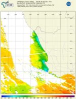
Interesting to see that the NASA sensors cannot/do not scan through the clouds which, as you all know, are water vapour themselves, or don't show a reading for the clouds.
Also interesting to note how much cooler Benguela current water is pressed up against the southwestern Cape coastline, fringed by the warmer Agulhas current water. I would have expected, especially with the couple of days of strong SE we have had, to see the water warmer than is represented on the map.
That said, judging by the trend, the warmest water is still heading toward the coast from the SE direction. Could be good for bronzies on Sunday...
Also interesting to note how much cooler Benguela current water is pressed up against the southwestern Cape coastline, fringed by the warmer Agulhas current water. I would have expected, especially with the couple of days of strong SE we have had, to see the water warmer than is represented on the map.
That said, judging by the trend, the warmest water is still heading toward the coast from the SE direction. Could be good for bronzies on Sunday...
Only radar goes through clouds. I don't think one of the main aims of the MODIS sensor was to measure SST but it was something that was developed over time. it is supposed to be fairly good though. The advantage is that it is fairly high res (=- 500mx500m) and most weather sats are much coarser. The imagery is also free so you get loads of people all over the world using it and developing applications for it. I think the 2 sats are at the end of their lifespan though and are going to be replaced by NPOESS ........google the acronym, it is not a swearword